 Gorean Map by _Marcus_ of ArI had never linked a map of Gor due mostly to the proliferation of maps on the interweb.Also due to the inordinate amount of work involved, I've never attempted to independently create one of my own, nor to even corroborate the works of others. However, if there is one person's work I would trust to link from my site, it would be the map created by _Marcus_of Ar. I have personally met and shared drink with Marcus. During his visit to my home we discussed the time and effort he spent on his map. His map, in his own words, in based on the first 25 books. Indeed I received it from him in 1999, long before Witness of Gor was published. I point this out as a disclaimer that any information from books 26 and onward, which modifies the map of Marcus, is not his fault. Here now are his notes in which he describes his research and how he came to place the map features where he did. I make no pronouncements on these matters, but report them as I find them. Arrive at your own conclusions. I wish you well, Fogaban Information about the Gorean Compass Directions can be found here. (in the words of _Marcus_ and his map below) This unofficial map of known Gor was assembled by me as part of an ongoing project, through which I hoped to gain a better understanding of the action described in John Norman's Gor series, and as an aid to any who felt that such a map would enable them to better visualize Norman's fictional world. The details involving such matters as the shape of the Gorean super-continent, as well as many of the relative distances and the overall details of the various coastlines, is, of course, completely conjecture on my part. I have taken great pains to insure the accuracy of the map according to the sparse information set forth in the books themselves, and to correct any seeming inconsistencies on Norman's part. In most such case, I attempted to create the map in such a way as to eliminate or logically explain any such inconsistencies in Norman's descriptions. While I do not delude myself that, if Norman himself does indeed have a working map of his fictional world, it is identical to my own, I can only hope that there is a certain amount of similarity between his vision of Gor as set forth in the books, and my own interpretation of his written words. The information I drew upon to create this map is detailed here, culled from countless readings of the 25 Gor books and long collected by me in a separate notebook specifically for this purpose. Additionally, certain features mentioned in the books I have not bothered to place on the map, due to the fact that they were dismissed as being unimportant or were literally too tiny to matter (examples of this would be the various small skerries and tiny inlets mentioned in Torvaldsland, and places such as "the Seven Meadows of Salerius," which are, in effect, tiny meadows. When one creates a continental map one does not place ponds and individual trees on it.) Also, the file mainmap.gif is the most up-to-date version of this map. The quick reference portion of it, derived from Version 1, may not perfectly match up with the main file. This is due to the fact that I am constantly upgrading the main one, whereas I rarely mess with the quick reference one. Eventually I will update it as well. Below is the information I compiled while researching this project, garnered from literally going over all 25 Gor books one line at a time. Some of what I learned I have not included, as it was based on conjecture... for example, in order to estimate how far Thentis is from Ko-ro-ba, one must know how far a fresh tarn can fly in a single day; in order to figure out how far Fortress of Saphronicus is from Ti, one must know how far a person can travel overland on foot, heavily laden, in a week, etc. For the record, a trained warrior on a good road averages 40 pasangs a day on the march (though he can cover over 100 pasangs a day if he is in a hurry), a good tarn can cover 68 pasangs per Ahn (40 mph) on the average (with suitable periods of rest) and according to my map the overland trek which Tarl made from the Sardar to the land of the Wagon Peoples at the beginning of Book 4 took him over eight months. This works, since Norman says in that book that Tarl travelled from the month of Se'Var (January) until the early autumn of the same year. I hope he had a good pair of walking sandals. Here is the bulk of the specific info I gathered, in no particular order. I have not included the page/book number where I found the references since I didn't bother to list that in my notes, just the information itself. If anyone wants to double check my work, you'll just have to go through the books line by line the way I did. "High" on the map (north): Ax Glacier, Torvaldsland, Hunjer, Skjern, Helmutsport "Lower" on the map (south of above): Kassau, Northern Forest, Laurius River, Laura, Lydius Still lower: The islands (Cos, Tyros, Teletus), Vosk Delta, Port Kar Inland of the above: Ko-ro-ba, Mountains of Thentis, Thentis South of the above: Many other cities, Tharna, Voltai Mountains, Ar, Cartius River Far south: Turia (near shore of Thassa), Islands (Anango, Ianda), (on the coast) Schendi, Bazi Plus: Hundreds of other cities, promontories, peninsulas, rivers, inland lakes, seas (NOTE: I have purposely refrained from depicting the hundreds of cities, inland lakes, and seas which he mentions but doesn't name, and mainly just stick to what the books do say.) Unexplored Territories: E of Voltai Mts. and Mts. of Thentis, W of Cos and Tyros, areas above Schendi (S of Vosk River and W of Ar) Island of Cos: 400 pasangs W of Port Kar. Mountains on E side of island, W side is flat. Has four cities: Telnus, Selnar, Temos and Jad. 100 pasangs W of Cos, is Western border of known Gor: "The World's End." Island of Tyros: All mountainous. 100 pasangs S of Cos, hundreds of pasangs W of Port Kar. Has two large cities: Kasra, Tentium. Maelstrom located SW of Tyros, in which the wreckage of ships occasionally appears. Independent Islands, N of Cos, form archipelago shaped like a NE leaning scimitar Northern Trade Islands: Scagnar, Farnacium, Hulneth, Asperiche. Far N: Hunjer and Skjern, W of Torvaldsland. Asperiche: Merchant Island in Thassa, S of Teletus and Tabor Anango: Merchant island in Thassa, in far S, almost at the edge of explored Gor Ianda: Merchant Island N of Anango, in Thassa Teletus: Exchange Island in Thassa Tabor: Island, shaped like a drum, S of Teletus Scagnar: N, island offshore from Torvaldsland Several islands, some several pasangs in length, in mouth of Ua River Vosk R: 40 pasangs wide, passes frontiers of Ar to Tamber Gulf. Far S of Ko-ro-ba, far N of Ar, flows W, empties into Rence (Vosk) Delta on Thassa Laurius River: Slow, winding river, N of the Vosk River, inclines more to the SW than the Vosk. S of Laurius are cultivated lands, N of Laurius are Northern Forests. Verl River: Tributary of Vosk River, flows NW into Vosk Olni River: Large tributary of the Vosk, NE of the Vosk R. Issus River: Tributary of Vosk River, flows N to Vosk Cartius River: Actually three rivers, Cartius Proper, Subequatorial Cartius, and Thassa Cartius. The Thassa (or Northern) Cartius is located far S of Ar, feeds into the Vosk and was formerly the southern border of the Empire of Ar. It flows W by NW, enters the rain forests, and empties into Lake Ushindi. The Cartius Proper is as wide as the Vosk, and is surrounded by rain forests for much of its length. Ua River: Extremely large river (as wide as the Vosk) in the Equatorial Rain Forests. Connects Lake Ngao and Lake Shaba. Its source is Lake Shaba. Upper & Lower Fayeen Rivers: tributaries to the Cartius River, N or Tor Rivers Kamba and Nyoka enter Thassa W of Lakes Ngao and Ushindi Northern Forests: N of Laurius River. Far NE of Ko-ro-ba, cover hundreds of thousands of square pasangs. Eastern edge (?) frequented by slavers from Port Kar. (Here is another seeming incongruity of Norman's. He tells us that the Eastern Edge of the Northern Forests is totally unknown, but apparently slavers from Port Kar visit it occasionally. I have given the Northern Forests an Eastern edge, therefore, which can be reached by Thassa if one sails to the Polar Sea and slips through the glacial ice of the area between Axe Glacier and the Polar Plain, during the summer. More logically, I have located the W edge of the Northern Forests on a descending isthmus, in such a way that there is another "Eastern Edge" above Lydius... which I suspect Norman was referring to in the first place. "Eastern" seems to be a typo. I bet he meant "Western Edge.") Swamp Forest of Ar: During the series we are alternately told that the Swamp Forest borders Ar to the N, and is located S of Ar. Possibly a typo on Norman's part (or his editor's). I have solved this by placing swamps forests both N and S of Ar. Equatorial Rain Forests, or "Jungles of Schendi": Cover thousands of square pasangs on the equator. Bordered on the W by Thassa. Home of the "great equatorial lakes" of Gor. Woods of Clearchus: 200 pasangs W of Sardar Mts. Voltai Mountains: Vast mountain range which rises from the midst of known Gor "like the spine of the continent." NE of Ar, E foothills are within pasangs of Ar, Voltai are the Eastern border of known Gor. Hrimgar Mountains: Tiers of interlaced mountains NE of Torvaldsland. Mountains of Thentis: NE border of known Gor, beyond which lie The Barrens. Home to flocks of wild tarns. Located above (North of) Voltai Range. Sardar Mountains: 1000 pasangs from Ko-ro-ba, in the North. Described as not being as large or impressive as the Voltai or the Mountains of Thentis. Ta-Thassa Mountains: Large mountain range; described as "sub-equatorial," located in Gor's S hemisphere, at shores of Thassa Torvaldsberg: Large mountain in N Torvaldsland, W of Thassa Tahari Desert "the Tahari Wastes" lies E of Tor, and is shaped like a giant, lengthy trapezoid, with eastern-leaning sides, hundreds of pasangs deep, thousands in length. Farther E, still more barren. The deepest wastes are located SW of Klima. Tor lies at the NE corner. (Here I was forced to take a bit of license, due to the prescribed position of Tor. I have the Tahari "leaning" eastward, only the lower, SE, part of it does the leaning; sort of upside down to what one might initially picture. This is necessary in order to accommodate the position of the large uncharted portion of the Tahari "east" of Tor. If Tor is at the NE corner, then there is no Tahari to the east of it, unless one "leans" it in the above manner) Ven Highlands: Home of jungle tribes in Equatorial Rain Forests, with descending plains drained by Thassa Cartius River. Lake Ngao: As big as Lake Ushindi, 2nd of the great equatorial lakes. Eastern extremity is vast river (as large as the Vosk River), Ua River. Lake Ngao is oval shaped, like a tribal shield. 100 pasangs E of Lake Ngao, Ua river is blocked by waterfall, "The Falls of Bila Haruma." Lake Ngao is 400 pasangs from Lake Ushindi. Lake Ushindi and Lake Ngao are separated by a swamp thousands of pasangs in area. The Villages of Unkungu are located on the NE shore of Lake Ngao; Nyundo is the central village of Ukungu region. Lake Ushindi: Drained by Kamba River and Nyoka River, a large equatorial lake. 6 Village Ubarates occupy the S shore of Ushindi, and floodlands, marshes and bogs lie West of the lake. The inland village of Nyuki is located on the N shore of Lake Ushindi. Vosk Delta: Large swamp/marshland at W edge of Vosk River, where it meets Thassa. Covers thousands of square pasangs. Tamber Gulf: At edge of Vosk Delta where it meets Thassa. Described as being "Shallow" in shape. Tahari Salt Flats ("The Salt Districts"): Several districts of the Tahari Desert where salt is produced, widely separated in the midst of dune country Southern Prairies of Gor: stretch from Thassa and Ta-Thassa Mts. to the S foothills of the Voltai Range, bordered on N by Cartius River Plains of Turia: Grasslands surrounding Turia, Far S of equator Margin of Desolation: Borders Vosk River, N of Ar. Area of man-made devastation designed as a barrier to prevent attack on Ar from the N. Later allowed to regrow and reforest, the area keeps its name. 200-300 pasangs in area. Sa-Tarna fields of Ko-ro-ba located toward Vosk River and Tamber Gulf Hills and meadows: Surround Ko-ro-ba to the NE. Pass of Tancred: Pass through Hrimgar Mts., NE of Torvaldsland Axe Glacier: E of Torvaldsland, Farthest N, in valley of Hrimgar Mts (between two mountains of stone). N border of Torvaldsland. Open Fields and Meadows: S of Laurius, 40 pasangs inland from Thassa, 120 pasangs S of Lydius Polar Plain: N of Axe Glacier, thousands of pasangs wide, hundreds deep Places located between Argentum and Corcyrus, from West to East, in order: Fields of Hesius, Lake Ias, Issus River, Hills of Eteocles, Pass of Theseus (not shown on map), Plains of Eteocles Plains of Eteocles: 100 pasangs W or Corcyrus Hills of Eteocles: SW of Corcyrus, 100 pasangs from Issus River Canal of Bila Haruma: Man-made canal from Lake Ushindi to Lake Ngao Exchange Beaches: 50 pasangs N of Lydius. (I didn't indicate these on the map. A beach is a beach, and there are a lot of them on the shores of Thassa.) Boswell Pass: Pass through Mts. of Thentis to Barrens Runestone (Torvaldsmark): On skerry of Einar, S border of Torvaldsland. Marks the S border of Torvaldsland. Saleria: Area encompassing territories of four cities, from "Meadow of Saleria" where Salerian Confederation was formed. Salerian Confederation: NE of Vosk on Olni River. Kasra: a desert (river) port, trades in salt. W of Tor, at the junction of the lower and upper Fayeen Rivers, on the Lower Fayeen. (Norman re-uses this name as a city on the isle of Tyros.) Tor: NE corner of Tahari, surrounded by hundreds of communities, some hundreds of pasangs apart. Area to west of Tor is occupied and widely inhabited. Tor is located far SE of Ar, far N of Turia. Khurtzal: village, upriver from Kasra on the Lower Fayeen River. N of Tor, overland. Teehra District: District SW of Tor, bordering on the Tahari. Oasis of Nine Wells: Tahari settlement S of Tor Oasis of Farad: Tahari settlement, location not specified Oasis of Stones of Silver: Tahari settlement, location not specified Oasis of the Sand Sleen: Tahari settlement location not specified Klima (Salt Pits of Klima): 1000 pasangs from any civilization, in the Tahari. (Not entirely accurate; it lies 24 days march SE from Kasbah of the Guard of the Dunes. Depends upon your definition of "civilization," I suppose.) Oasis of Two Scimitars: Tahari settlement, location not specified, described as "out of the way." Oasis of the Battle of Red Rock: Tahari settlement Far E of Nine Wells. Last Oasis E for 2000 pasangs. Western border of "the Dune Country." Turmas: Turian outpost in the SE edge of the Tahari. (Norman uses a variation of the same name, "Turmus," to specify another city at the edge of the Vosk Delta.) Kasbah of the Guard of the Dunes: E of Red Rock Oasis of Four Palms: Far S of Red Rock, farther from Klima than from Red Rock, closer to the edge of Dune Country than Red Rock Schendi: Equatorial free port on Thassa. Known for its famous Harbor, which is 8 pasangs wide, 2-3 pasangs deep, and opens onto the Nyoka River at the harbor's E end. The Nyoka flows from Lake Ushindi into Schendi Harbor, then into Thassa. Ukungu: Sovereign free state inside Empire of Bila Haruma Helmutsport: Free Trade Port on Thassa, coastal city in the N. (Described as being both N of Kassau and S of Kassau. I have put it S of Kassau.) Lydius: City at mouth of Laurius River on Thassa. S of Kassau. Laura: Trade town 200 pasangs upriver on Laurius from Lydius, inland from Thassa Thentis: City in Mountains of Thentis, has some agriculture. Located in fertile valley. Treve: Mountain city, 700 pasangs above (N of) Ar, located between Ar and the Sardar Mts. (According to Norman this city's location is secret and is not indicated on any map, only the territory claimed by the city. I have obeyed this convention therefore.) Free Trade Ports under Merchant Law: (North) Lydius and Helmutsport. (South) Schendi and Bazi. Ko-ro-ba: High in the N latitudes of Gor, below Northern Forests. Hills and Meadowlands NE of Ko-ro-ba. 1000 pasangs from Sardar Mts. SE of Laura. NW of Ar. Coastal cities: Port Kar, Helmutsport. (Far South) Schendi, Bazi. Fortress of Saphronicus: Former merchant outpost, now city, within several days march of city of Ti City of Ti: N of Tharna, situated on Olni River (tributory of the Vosk River). Tabuk's Ford: Peasant village, 400 pasangs N and slightly W or Ar Ar: Massive walled city of thousands of cylinders. Formerly the seat of the Empire of Ar. Located on "the plains" of central Gor, between Vosk R. and Cartius R, and between Voltai Mts. and Thassa. Described as being "low in the temperate zone of the Northern hemisphere of Gor." Port Olni: Located on N bank of Olni River, S of Ti and N of Vonda Lara: City at juncture of Vosk and Olni Rivers, on S bank of Olni, N bank of Vosk Argentum: City, NW or Ar Corcyrus: City, S of Vosk River, SW of Ar, NE of Argentum(?), 1000 pasangs West of Thassa(?) (Note: this is what I personally call the "problem of Corcyrus": Not only can Corcyrus NOT be SW of Ar AND NE of Argentum, since Argentum is supposedly NW of Ar, but since Thassa is to the W and the Voltai Mts. are the Eastern border of known Gor, it cannot be "1000 pasangs West of Thassa." I have placed it 1000 pasangs EAST of Thassa, however, and put it on a more or less straight W-E line with Argentum, in order to stay as close to the description as possible. No way around this one; this is a conundrum, or a typo on Norman's part, one or the other.) Vonda: City, located on Olni River, on N bank, N of Lara Venna: Resort city, 200 pasangs N of Ar, between Ar and Vosk River Hochburg: City in S Voltai Mts. Tarnburg: City, 200 pasangs NW of Hochburg in S Voltai Mts. Brundisium: Port city on Thassa, 100 pasangs S of Vosk Delta (on Mainland) Market of Semris: Small trade city SE of Brundisium. Vosk River Towns, from the West to the East, in order: Turmus, Ven, Tetrapoli, Port Cos, Tafa, Victoria, Fina, Ragnar's Hamlet, Hammerfest, Sulport, Sais, Siba, Jasmine, Point Alfred, Jort's Ferry, Forest Port, Iskander, Tancred's Landing, Whitewater. Most major towns on N bank of Vosk River. Jasmine and Siba are "centrally located between Olni River and Vosk Delta." Whitewater and Lara are far E on Vosk River, where Vosk River joins the Olni River. Turmus: Last major river port on the Vosk River before the Vosk Delta. Located on N bank of Vosk. Ven: Vosk River town, E of Turmus, on S bank of Vosk. Whitewater: E of Ar's Station, Farthest E on Vosk, but W of Lara (on Olni) Forest Port, Iskander, Tancred's Landing: All between Ar's Station and Whitewater. Victoria: On N bank of Vosk River, between Fina and Tafa Samnium: City, 200 pasangs E and a bit S of Brundisium Ar's Station: Town on S bank of Vosk River, E of Jort's Ferry (on N bank), W of Forest Point (on N bank) Torcadino (Alternately "Torcodino." I have chosen the more common of Norman's spellings): City, located on "Flats of Sarpeto" at junction of five roads, SE of Brundisium, SW of Ar. Holmesk: Town, 100 pasangs S of Vosk River, between Ar and Ar's Station Teslit: Town, N of Holmesk, midway between Holmesk and the Vosk River. Rarn: City, SE of Tharna, known for its silver mines. Tharna: City in Northern hemisphere. (Described as being far NE of Corcyrus, but since Corcyrus is so damn hard to place accurately, it winds up being far N and a bit W of that city. Since Tarl, when travelling from the ruins of Ko-ro-ba toward the Sardar, passed through here, I have placed it more or less directly between Ko-ro-ba and the Sardar. Since he was travelling on foot with limited rations, I have placed it no more than several days hard march from Ko-ro-ba, also.) Port Kar: 100 pasangs from NW edge of Delta, 100 pasangs S of nearest solid land Fort Haskins: Former fort city at E edge of Boswell Pass, once attacked by Port Olni (level with that city) Kailiauk: Trade town on Frontier of Barrens, NE of Fort Haskins Kassau: Northern coastal Free Trade Port city located at inlet of Thassa, with the Northern forests behind it. NW of Port Kar. NW of Mts. of Thentis. W of Torvaldsland. Harfax Besnit, Esalinius: Three cities, within 100 pasangs of the edge of the Woods of Clearchus. Rorus: Village located by tracing the overland trade route five days SE (by caravan) of Ko-ro-ba, towards Ar, then proceeding several days SW overland (on foot) from there. Rarir: Village located S of Vosk and near to Thassa. SW of Ko-ro-ba. Roads: Genesian Road (links Brundisium and other coastal cities in S), Northern Salt Line (East/West), Northern Silk Road (North/South), Pilgrims' Road (to Sardar), Eastern Way "Treasure Road" (links Western cities to Ar), Viktel Aria (Main road, runs North out of Ar toward Vosk, called "Vosk Road" in Northern environs), Road of Clearchus (Western road out of Sardar Mts.), Road of Cyprianus "New West Road" (alternate Western road from Sardar Mts.) Places without locations: Fields of Cardonicus, Piedmont (city), Talmont (city), Rive-De-Bois (city), Rovere (city), Kargash (city), Edgington (city), Teveh Pass, Gordon Heights, Plains of Sanchez, Tarnwald (city) (I have attempted to place some of these cities and features logically, according to my own perception of them as described in the books. I have taken clues from such things as their names... for instance, Rive-De-Bois means "River of the Woods," so I have placed it at the source of the Laurius; Talmont might be seen as meaning "Greetings Mountain" so I have placed it at the far Western edge of the Voltai, Tarnwald might be taken to mean "Tarn Wild" so I have placed it north of Thentis, near the Barrens, etc. A few of these places I have just placed on the map where it seemed they fit in... Kargash sounds Southern, so it is S of Turia, and so on. You get the idea.) Cartographer 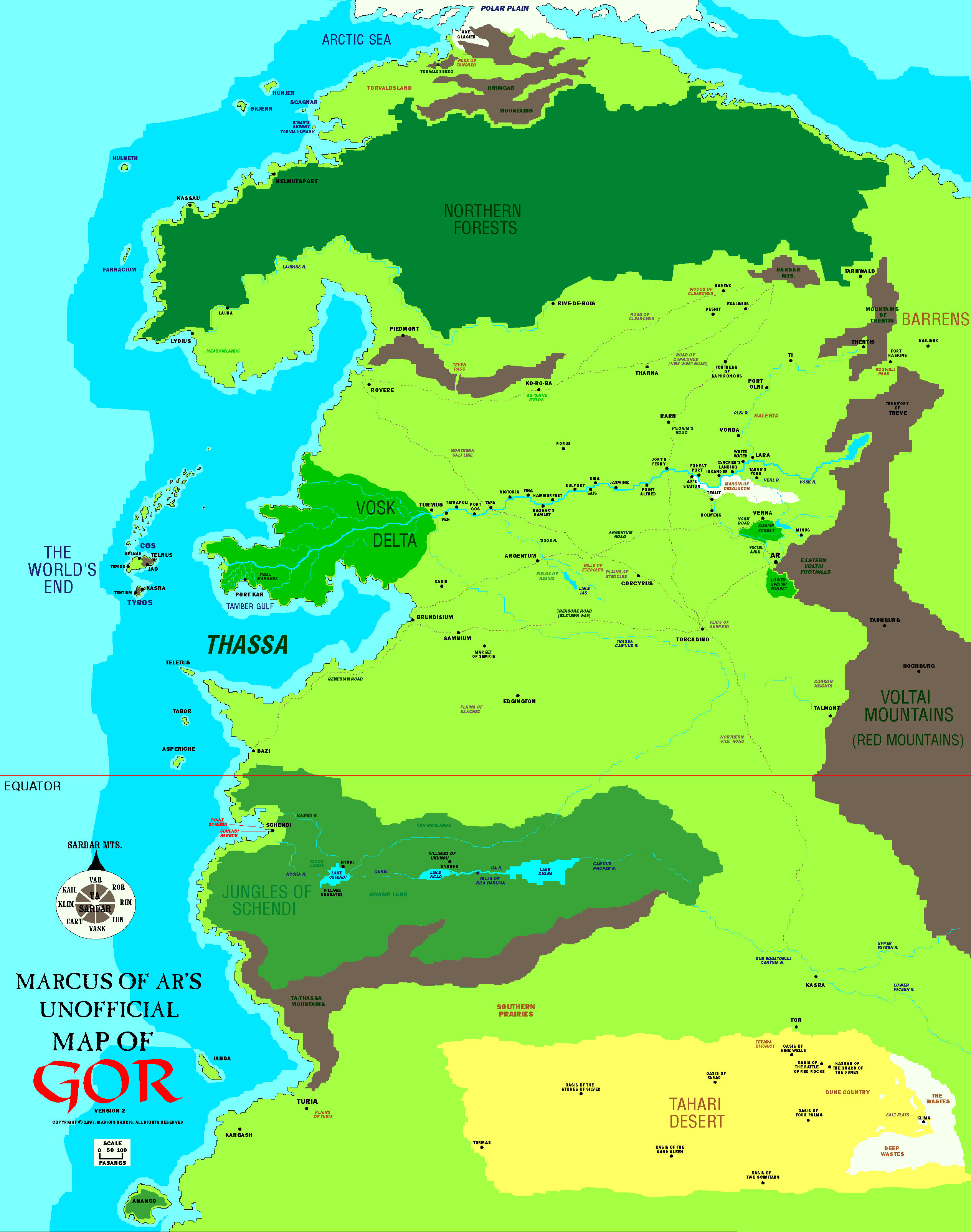
×
|       
| ||||||||||||||||||||||||||||||||||||||||||||||


